Within the 185 Billion gallons of annual discharge from the river's large drainage basin through the easternmost 20 miles of the Mohawk River, ice usually complicates passage of discharges, accompanied by graphic publicity. We often have rationalized unpredictable ice-jams as a "cause" of flooding. Other weather conditions produce extraordinary discharges, always a threat to low-lying properties at Schenectady, as proven clearly in the recent free-flow examples of the flood during June 2006 and the "near-flood" of 16-17 April 2007.
Such free-flow events inform us why flooding recurs. They provide evidence, potent evidence, that the Vischers Ferry Dam's century-old design, unchanged today, strongly influences or is a major contributor to the recurring canal/river floods at Schenectady. The Vischers Ferry Dam's inflexible impoundment of the river as the raised and unmanageable Niskayuna-Schenectady Pool in the Barge Canal and NYPA systems imposes excessive "poolside" vulnerability at Schenectady, regardless of season. The evidence also strongly suggests the nature and scale of the needed constructive 21st-century response.


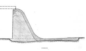
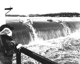
In the above schematic "section" drawing of the power-dam that provides the 27' lift from the Cohoes Pool for navigation and a fall to spin power turbines, the pair of dashed lines at top-left represent (a) the higher navigation-season level produced by the flash-boards placed in sockets on the crest and (b), level with the crest, the "normal" Niskayuna-Schenectady Pool. The accompanying photo shows more than four feet of water overflowing the nearly 2,000-feet length of the crest after ice break-up.
Literally underlying the swiftly flowing strong current passing Schenectady followed by the massive overflows at the dam, more is happening — much more, and of heavy consequence.
Every large discharge must overflow the ever-present contained volume of the Niskayuna-Schenectady Pool's entire length from the base of Lock 8 eastward as a virtual ramp to the crest of the Vischers Ferry power-dam, starting toward flood-stage.
Compounding the designers' deliberate excluding of any means within the dam to prepare for surging discharges and their reliance on "easy" overflow along its length, even with flash-boards mounted, the design of a high vertical upriver face bluntly opposes discharges and undoubtedly results in significant subsurface swirling turbulence, perhaps a counter-flow along the bottom of the Pool and upriver — hence increasing the volume and height of the pool more than the surging discharge alone.
After the 1920's filling of the abandoned Erie Canal within the city, no serious doubt can remain that the "passive" basic design of this power-dam structure with its Niskayuna-Schenectady Pool, "operating" for nine decades-plus now, is the clearly central factor among most of the recurring floods at Schenectady. Moreover, the impact far exceeds the overall effects of any truly significant constriction at the geologically walled bends and narrowness below Rexford.
Ongoing open vulnerability at Schenectady remains too-long after the 1910-1916 floods early in the existence of the dam and the outcry then from Schenectady to NYS officials. Nobody appears to have acted in any substantial and persistent way (a) to define the engineering issue or issues beyond further question, doubt or debate, or (b) to have exerted open-minded effort to improve conditions leading to the recurring floods here.
Furthermore, the information gathered during this concept-level investigation clearly refute the credibility of all reported prior statements by NYS officials about the presence of any possibly flood-relieving gates in the Vischers Ferry Dam, their faulty condition, etc.
After the flood of 1916, the NYS engineers' promised investigations into the design of the Vischers Ferry Dam apparently succeeded in "stonewalling" or "whitewashing" Schenectady's expressed concerns about the surge of flooding starting in 1910 (any documents reporting the investigations seem to be unavailable).
During the late-1970's, official NYS investigations and reports about flooding at Schenectady were defensively status-quo regarding any implication that the Vischers Ferry Dam significantly influences flood-stages 7.5 miles upriver and those responses therefore were inadequate, even erroneous, as constituting an objectively conclusive review (records of communications seem unobtainable).
Any as-is continuation is unacceptable — the early-20th century engineering design for this dam was solely to facilitate navigation and generate power. "Flood-control" at Schenectady, per the Corps of Engineers' decades-earlier intent for an earth levee/wall, is not a proper objective. "Control" would not deal with the local core of the problem — the unmanageable canal-pool above a "passive" dam. We need flood-mitigation, at the basic constriction of flow. The County and City of Schenectady should not tolerate any further "business-as usual" by NYS officials regarding the faulty, flood-inducing original design of the Vischers Ferry Dam and its incapability for short-term controlled releases to lower the Pool briefly at Schenectady.
Modifying the Vischers Ferry Dam to provide a significant but temporary increase of discharge or throughput below the crest would be very effective. For example, gradually and temporarily lowering the Pool at Schenectady by only 4-5 feet while accommodating a torrent from upriver with no (or minimal) overflow along the crest would reduce most flooding of basements (and more) experienced during the past four decades. For example, a present-day flood at 228 feet minus a 4-feet lowering equals 224 feet, a level where the canal/river is into the park — but not much more (at that flood-level, "water starts to enter the Stockade neighborhood", as stated on the National Weather Service website). SCCC would gain significantly in several ways.
Mitigating, perhaps preventing many canal/river floods is very possible, while also (a) meeting all normal navigational needs, (b) sustaining the valuable hydro-production of electrical power at a reasonable level and the carefully managed throughput to replace most overflows and (c) avoiding any further endangerment among low-lying properties in the Cohoes Pool downriver.
A comprehensive technical investigation of the Vischers Ferry Dam and the lower several miles of the Niskayuna-Schenectady Pool (at least to Rexford) is fully justified, and at the earliest practical time. Moreover, investigation must focus on all influences of the cross-section and fixed height of the dam (including the flashboards) toward turbulence and possible backwater within the impounded canal-pool, on which all flooding begins.
A fresh, forward-looking, can-do and out-of-the-box approach by the Canal Corporation surely can devise, propose, finance and incorporate new features, systems, timely procedures etc. to cope actively with the short-term adverse dynamics of the canal/river, superseding the historically "passive" constructed form of that dam. An early-21st Century resolution of the dam's deficiencies toward flood-mitigation appears well within the capabilities of the Canal Corporation as a subsidiary of the NYS Thruway Authority and its long history in engaging experienced specialists.