[View 9x enlarged version (593K)]
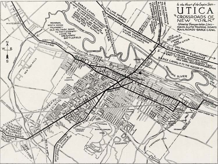
Map of Utica: "Crossroads of New York" — showing transportation lines — main auto touring roads, railroads, Barge Canal.
Notations on map [moving roughly northeast to southwest] include:
- Black River Highway / to Lake Champlain / to Adirondacks
- To Watertown, Thousand Islands, St. Lawrence River, Montreal, Quebec
- North Shore Mohawk Highway (to Rome) called Riverside Drive in Utica city limits
- Old Deerfield Corners / now North Utica
- Old Mohawk Turnpike (New York to Buffalo highway) locally called Herkimer Road / east to Schenectady, Albany, Troy, New York, Boston & Philadelphia
- Barge Canal to the Hudson at Waterford and Troy and Albany
- Mohawk South Shore Highway to Ilion
- Barge Canal / west to Lake Ontario at Oswego / west to Lake Erie at Buffalo / Utica is half-way point on Barge Canal from Troy on the Hudson River to Buffalo on Lake Erie
- Mohawk South Shore Highway / old military road to Fort Stanwix / leads to Oriskany battlefield
- Bridgewater Turnpike to Unadilla River & Binghamton
- Seneca Road / to Syracuse, Rochester & Buffalo / to Clinton & Hamilton College